|
Britain's Floods!
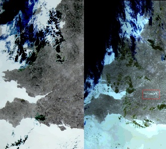
Photographs
with thanks to ESA.
WHY is Britain
suffering from severe floods this summer? Will climate change bring
more frequent and intense storms in the future? These questions have
been on lots of lips over the last few weeks.
With Merseyside being under threat from flooding as the climate
changes many of us should be taking note. Though the floods have
been in other parts of the UK, the impact has been nationally felt
and will remain felt for years to come with increased insurance
prices. Also taking notes of the collapse in the basic
infrastructure of the UK, that has not only affected local people
but also local businesses in the areas affected and nationally.
For example here at Southport Reporter, we did not expect our
servers to go down.
On 27 July 2007 The
Natural Environment Research Council held a national press briefing
where we were told that they are funding experiments by scientists
in universities and its own research centres, to provide answers to
these questions. The research data they produce helps to underpin
many of the flood forecasts and defence mechanisms provided by
organisations such as the Environment Agency.
The media was informed that The Centre for Ecology and Hydrology (CEH)
has carried out a preliminary assessment of the reasons behind the
exceptional flooding we are currently experiencing in the UK. and
have informed the media that:- "It appears there has been a
combination of contributory factors - the
jet stream
has followed a route further south than usual, and the high pressure
cell coming from the
Azores has bypassed
Britain. In addition, a sustained sequence of low-pressure systems
over the past 12 weeks has produced exceptionally high rainfall
levels. So while Britain suffers grey skies and prolonged flooding
most of Europe basks in sunshine and high temperatures, which bring
their own
problems."
Professor Alan Jenkins, Director of the CEH Water Science Programme
said that:- "The combined May and June rainfall total is the highest
on record for the UK, by a considerable margin. Flood risk during
the summer is usually diminished because the ground is dry. This
year, because of the record rainfall in the late spring and early
summer, accompanied by widespread flooding in June, the soils were
so wet they couldn't cope with the heavy rain in July. Added to
that, the intense rainfall overwhelmed many urban drainage systems,
causing localised flash floods."
"An indication of the rarity of the hydrological conditions
experienced this summer is provided by the recent increases in
groundwater levels in some parts of eastern and southern England.
Usually groundwater levels decline between May and September because
there isless rainfall to replenish them. But this year groundwater
levels in the Cotswolds rose rapidly and by 24 July stood above
normal winter levels." CEH told us.
Professor Jenkins said:-
"The July 2007 flooding is clearly an extreme event and, as such,
difficult to link it with.."
...continued...
|
...continued... "...any
trends in observational records or predictions associated with
favoured climate scenarios.
It does serve to underline our
vulnerability to very exceptional summer rainfall and the, as yet
poorly understood, changes in the position of the jet stream."
You can view the full analysis on the CEH
website
website Recent_UK_floods
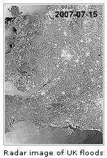
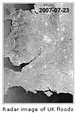
The British Geological Survey (BGS) has also been working hard, we
were informed. As part of the NERC response to the flooding, BGS has
photographed flooded areas from the air.
The low altitude photographs the BGS have taken often at around 600m
(2000ft) have captured and recorded flooding in the worst affected
areas around Oxford, Gloucester and Tewkesbury. They will use these
photographs to compare images with their new Geological Indicators
of Flooding Map. The map shows where floods have occurred in the
past few thousand years and the pattern they follow will be a useful
guide to where future floods are likely to occur.
Marietta Garcia-Bajo from the Geological Indicators of Flooding
Team, BGS said:- "This summer, flooding has affected a great many
people. Collecting information when river�s flood means that we can
improve our understanding of ancient floods, shown on geological
maps, and help homeowners and planners to manage floods in the
future.
The BGS Geological Flood Indicator data shows many areas that have
been flooded in the past. The floods happening today tend to follow
the same routes as ancient flows, and these are often shown on
geological survey maps."
Dr John Carney, Principal Geologist, BGS said:- "From the air, I was
able to see just how extensive and dramatic the flooding has been
around Oxford, Tewksbury and Gloucester. Our flood maps show that
vital installations such as the Mythe Water Treatment Plant could be
placed at risk by such extreme events. This modern flood matched
long-gone rivers and channels shown on our geological maps."
Dr Andy Gibson, Leader Shallow Geohazards Research, BGS said:-
"Although events like these are very rare, they affect many people,
and it is important that we learn from them. Collecting information
at the time of the disaster helps us understand how people are
affected by geology and how to best manage geohazards in the
future."
The Proudman Oceanographic Laboratory (POL) in Liverpool, is home to
several research and monitoring programmes concerned with sea level
rise and coastal flooding. This is one of the issues that will
affect Merseyside heavily in the future. One of its major programmes
involves continuous monitoring to provide a global data bank of sea
and land level changes around Britain's coastline.
POL scientists are also responsible for the day to day operation of
the Storm Tide Forecasting Service, in collaboration with the
Environment Agency and the Met Office. They provide the 48 hour
warnings that the Environment Agency uses to make decisions on when
to raise flood defences, such as the Thames Barrier which protects
London from major tidal surges.
POL is collaborating with the Met Office Hadley Centre in a project
that forms part of the Environment Agency's Thames Estuary 2100
programme. Using computer models, the project will address the issue
of how to protect the Thames from flooding this century, by
indicating whether or not extreme water levels will change in the
future. It is also running programs like this for other areas like
Merseyside as well.
Dr Kevin Horsburgh said:- "The Thames Estuary 2100 programme will
provide a decision framework for flood defence strategy in the
region over the next 100 years. There are obviously many engineering
options, and our long term records of sea and land levels are
critical to those decisions"
More information about the POL see
www.pol.ac.uk.
So what can we expect for the future? "Merseyside and other parts of
the UK will be increasingly threatened by flood risk from extreme
conditions ranging from unpredictable meteorological events and
other hydrological events and that's not forgetting coastal
oceanographic processes. The events of late show we must take action
and address the future. We must change our life styles and the way
we conduct our selves, to take in to account the changing
environment. If not we run the risk of reputedly suffering from the
effects of climate change."
ESA Photographs with
thanks to ESA. If you would like to see more images highlighting the
extreme weather conditions hitting Europe and also a slide show of
the UK's probabilistic rainfall then visit this
link. |